
A numerical cloud model is indispensable for both understanding cloud and precipitation and their forecasting. A sever thunderstorm is composed of strong convective clouds. In order to perform a simulation of this type of storms, a very fine-grid system is necessary to resolve individual convective clouds within a large domain. Since convective clouds are highly complicated systems of the cloud dynamics and microphysics, it is required to formulate detailed cloud physical processes as well as the fluid dynamics. A huge memory and large-scale parallel computing are necessary for the computation. For this type of computations, we have developed a cloud resolving numerical model which was named the "Cloud Resolving Storm Simulator" (CReSS). The model is designed for parallel computers including "the Earth Simulator".
We performed a simulation experiment of a tornado-producing supercell observed on 24 September 1999 in the Tokai District of Japan. The simulation was aiming at resolving the vortex of the tornado within the supercell. The result showed that an intense tornado vortex was formed at the central part of the intense updraft of the super cell (Fig.1). The important point of this simulation is that both the supercell and the tornado were simulated in the very fine and uniform space resolution. The tornado was produced purely by the physical processes formulated in the model. A detailed analysis of the simulated data will provide an important information of the tornado-genes is within the supercell.
Fig.1 Three-dimensional computer graphics of the simulated tornado. The gray scale indicates the potential temperature perturbation (C) at the surface. The gray scale shows vorticity associated with the tornado in three dimension. The indicator on the upper left side is time from the initial in minutes. (The computer graphics were produced by Computer Technology Integrator CO.,LTD. )
From September 11 to 12 in 2000 an extremely heavy rainfall attacked the Tokai district. Heavy rainfall was maintained for about 14 hrs and maximum total rainfall amount reached 564 mm at the Tokai city. On the basis of the radar-data analysis, we found line-systems that extended from the south to the north were stagnant for about 5 hours over the Bay of Ise, although cloud-clusters moved from the wes t to the east. Line-systems intensified at a period of 2 or 3 hours after the passages of cloud clusters. The modified wind field by the passage of cloud-clusters helped the intensification of the line-system. Hypothetical model on the intensification process of a precipitating line-system related to the passage of cloud-clusters summarized in the schematic figure. 1) Before cloud-cluster passes over the line-system, the southeasterly wind in the low-level was intensified . New cloud formed successively in the eastern side of the line-system and formed a part of the line-system. Cloud-cluster also supplies precipitating particle from upper level. 2) During the core of the cloud-cluster is passing, the convergence of cloud-cluster intensifies the convective activity of the line-system. The line-system becomes the most intense about 10 minutes after this stage. 3) After cloud-cluster passed, the line-system goes to the decaying stage.

Fig.2 Hypothetical model on the intensification process of a precipitating line-system related to the passage of cloud-clusters. 1) before cloud-cluster passes, 2) the core of the cloud-cluster is passing and 3) after cloud-cluster passed.
For understanding the Baiu frontal precipitation systems, which have the multi-scale structure, it is necessary to investigate the three -dimensional structure of thermodynamic and water vapor fields and the source of the water vapor. Figure 3 shows a conceptual model of the three-dimensional structure of the Baiu frontal precipitation systems over the East China Sea. A broad stratiform region is generated in the north of the Baiu front. A cold pool is formed by evaporation cooling below this stratiform region and it strengthens the convergence in the synoptic front by its southward extension. Meso-alpha-scale lows with convective systems, which bring about heavy rainfall events, are often generated along this synoptic Baiu front. On the other hand, the "water vapor front" is formed in the southern region far from the synoptic front. It is generated by the contrast in water vapor along the coastline of the China and is developed by the extension into the East China Sea. It has a large supply of water vapor, but its low-level convergence is quite weak comparing to the synoptic front. When the synoptic Baiu front moves to the southward and merges into the "water vapor front", the intense rainband develops rapidly by increasing of water vapor flux and strengthening low-level convergence.
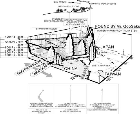
Fig. 3 Conceptual model of the three-dimensional structure of the Baiu frontal precipitation systems.
Recently, many special observations about the Meiyu/Baiu front are carried out and the structure of linear precipitation systems along the Meiyu/Baiu front is investigated. A linear precipitation system was also observed by the Doppler radar in the GAME/HUBEX IOP (GEWEX Asian Monsoon Experiment / Huaihe River Basin Experiment, Intensive Observation Period) in 1998. Figure 4 shows the cross-section of the linear precipitation system derived from the dual Doppler radar data. In this precipitation system, a warm and moist inflow from the southeast is located below the height of 1.5 km. An upper layer outflow to the southeastward is located around the height of 5.0 km. The radar reflectivity has its maximum at the height of 2.0 km associated with the low level moist inflow. Because almost saturated moist air exist around the ground surface, even weak lifting trigger the condensation and make a large quantity of the precipitation. This mechanism is important for heavy rainfall in the Meiyu/Baiu front with weak instability.
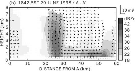
Fig. 4 Vertical cross section of the linear precipitation system analyzed by the dual-Doppler radar observation at 1842 BST (Beijing Standard Time) on June 29, 1998. Left and right correspond roughly to northwest and southeast, respectively. Vectors denote the storm-relative wind and grayscale shows the radar reflectivity.
A supercell storm in a moist environment developed over the Kanto Plain on May 24, 2000. We investigate the maintenance mechanism of this storm by using dual Doppler analyses and numerical simulations with the MRI-NHM (Meteorological Research Institute - Non-Hydrostatic Model). Figure 5 shows conceptual models of the supercell storm developing in the moist environment (observed on May 24, 2000) and that developing in the dry environment. The balance between the outflow and inflow below the supercell storm is an important factor in the maintenance of it. When the environment in the middle troposphere is dry, a strong outflow is generated by a strong downdraft, which caused by the evaporation cooling of the precipitation particles. A strong inflow is required in order to maintain the structure of supercell storm. On the other hand, when the environment in the middle troposphere is moist, an outflow is weak, because the effect of evaporation cooling is less. Therefore, a weak inflow is required in this case. We clarify the importance not only of the instability and the vertical wind shear, which have been proposed many researchers, but also of the humidity in the middle troposphere in order to maintain the structure of the supercell storm.
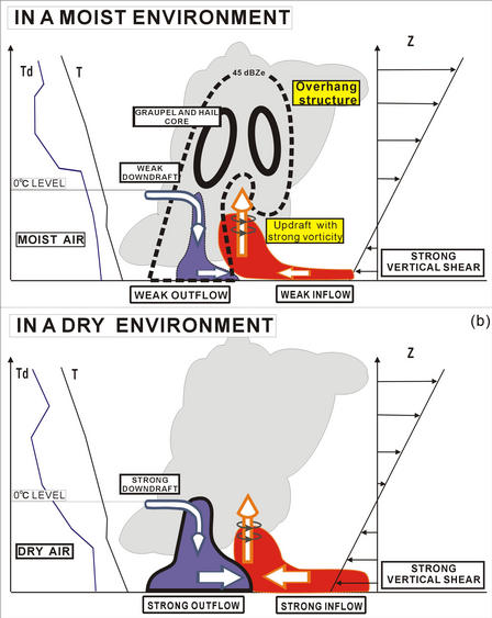
Fig. 5 Conceptual model of (a) the supercell storm developing in the moist environment observed on May 24, 2000, and (b) a typical supercell storm developing in the dry environment over the Great Plains.
During the summer monsoon season, the southern region far from the Meiyu front is generally covered by a Pacific subtropical high and there is less large-scale convergence. However, diurnal variation of convective activity was observed during the GAME/HUBEX IOP (GEWEX Asian Monsoon Experiment / Huaihe River Basin Experiment, Intensive Observation Period) in 1998. We examine the effective factors in the development of deep convective clouds over this region by using a two-dimensional cloud-resolving model. From the results of sensitivity tests, there are two effective factors; one is a large amount of a latent heat (moisture) flux from the surface. Since paddy fields can supply a large amount of latent heat flux into the lower atmosphere and are widely distributed on the Yangtze and Huaihe River Basins. The other is a moist environment in the middle troposphere. When the environment in the middle troposphere is moist, negative buoyancy by evaporation cooling around a cloud is relatively small; therefore, a shallow convective cloud does not lose its positive buoyancy and develops into a deep convective cloud. These features are summarized as shown in Fig. 4 and are different from those over the Great Plains.
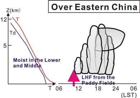
Fig.6 Schematic illustration of the diurnal variation of deep convective clouds over eastern China along with a typical sounding profile of the pre-storm condition.